

By: Tom
When preparing for a trip I rummage around for images of the area where I will be paddling and take advantage of Google Earth to fly over the area, trying to spot landing spots, prominent land features and potential hazards. These visual reference sources help in getting mentally prepared for the conditions and can be very useful in navigation. While this kind of visual due diligence removes some of the "surprise" factor in a trip, I've always felt more comfortable having some visual sense of the area I'm going to visit. That information seems to enhance rather than detract from the appeal of the trip.
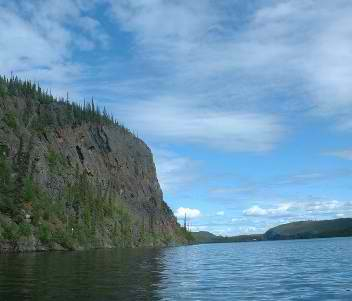
Below are some images of Great Slave Lake, the East Arm in particular. (More images accessible here.) These pictures tell me that in some areas landing spots will be hard to find because of the cliffs. From these photos and Google Earth it appears that there are few if any sandy beaches in the East Arm, even at the mouth of streams. Camping sites will be on rock for the most part, which will affect how tents are staked down. In many areas trees will be few in number and stunted, which means we won't be able to count on living windbreaks or handy branches in lieu of clotheslines. Choice of campsite location will be critical on windy days, as we will have to rely on cliffs and other landforms to shield us from the wind, especially as nighttime temperature hit the upper 30s.
I don't see much evidence of showers, electrical outlets or coffee shops either.


.
Looks spectacular, Tom. Are you strapping your 'yaks to a float plane? How do you get in? I can't wait to see pics, hear and read the stories. Have fun!
ReplyDeleteWe'll be strapping our kayaks to the pontoons of a float plane and flying about 80 miles almost due east of Yellowknife to the East Arm. If we're lucky, the plane will be able to pull up to shore and we can unload relatively easily. If not, we will have to unstrap our boats and get in them off the pontoons. From there we will have to ferry our stuff to shore. I hope we find a beach. The off-loading from a floating plane sounds like a recipe for wet gear and dunks in cold water
ReplyDelete