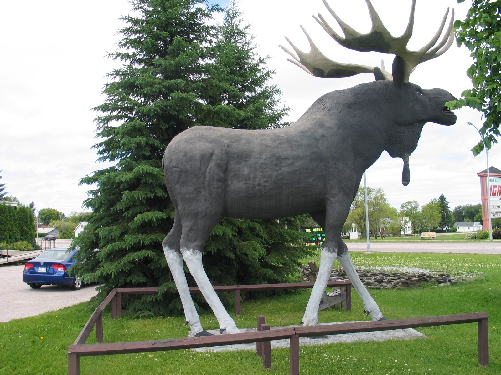
Saturday, March 19, 2011

MY PATH TO THE GREAT SLAVE LAKE PASSED THROUGH RED LAKE, ONTARIO


Kenora Moose

By:  Sarah

When we were growing up in rural Ohio, our family vacation each year (except the year we went to Alaska and the year we visited cousins in California) was a week of fishing in the northwest corner of Ontario with two other families. Every winter the three dads would pore over the terrain maps figuring out where the next trip would be.  They would then consult with George Slobodjan, a meat hunter for the gold mines during World War II turned owner of the fishing camp known as Howey Bay Camp in Red Lake, Ontario.  They would determine if George had boats for us to take into the wilderness or if we would be able to rent boats from First Nation people in the area.  George would also supply the local knowledge of the proposed destination.

Every July, right after wheat harvest, the three families would head north.  I have lots of stories of the giant goose in Wawa, the giant moose in Kenora, the locks in Sault Ste. Marie, waking up from an early morning start in time to see the oasis on the toll highway in Chicago, the bridge in Mackinac, counting freighters in Duluth, going through customs in International Falls, the secret pie stops in later years, but those details could fill an entire blog. Almost 50 years later, whenever I see any of the familiar landmarks along any of our travel routes, I'm filled with the same excitement I felt as a child. (Collection of Canadian roadside attractions here.)
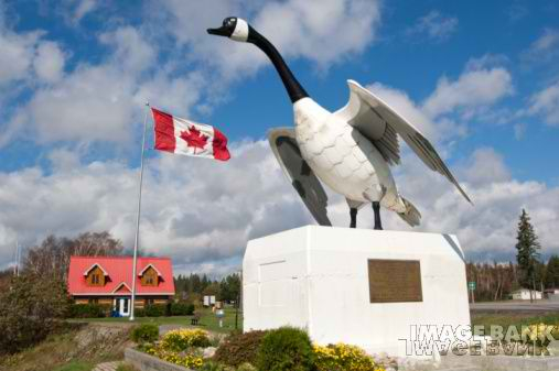
The Wawa Goose

We would arrive at the sea plane dock in Red Lake at the appointed time with boxes of groceries bought at the Red Lake grocery store, fishing licenses, boat motors, tackle boxes, canvas cabin tents, pup tents to store the food once we were in camp, sleeping bags, gas stoves, aluminum cook kits, cast iron skillets, camp tables and chairs, and old army duffel bags filled with clothes, life jackets, rubber boots, and all the other paraphernalia required to support three families with small children for a week in the wilderness in a manner that our mother's thought was appropriate.


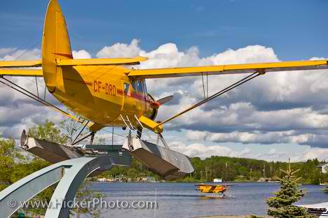
Red Lake Norseman Bush Plane Monument

The fly-in would take most of the day. Planes with names like Twin Beech, Beaver, and Flying Norseman  transported us into a world few others have experienced. By night fall our first catch of the week would be on the supper table and the big cabin tents and sleeping bags were ready for us to crawl into. Usually, someone would have already waded in over their boot tops and the ever familiar rules of “don't go near the water without your life jacket on,” and “don't go into the woods” would have already been repeated dozens of times.

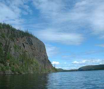
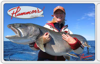
Oh, the adventures that would ensue. Days spent watching moose, catching fish, playing on beaches, eating fresh caught fish on a rocky point, endless mosquito bites, and an occasional bear sighting. Sometimes, we would portage into back lakes or around rapids and waterfalls to see what else there was to see. One time we even portaged 16 miles down a river to reach a Hudson Bay Outpost. One thing we never saw, unless we were close to a First Nation outpost, was other humans. It was easy to believe we were among the first white people to visit many of the lakes where we fished and certainly we were the first children “out there.”

In later years, Dad and I would go up on our own. But things kept changing. Red Lake got paved roads and cable TV, roads were built in to some of the lakes where we could only fly to previously, the canvas on frame freighter canoes were replaced with aluminum V hulls and converted into coffee tables and conversation pieces, and more people and more civilization continued to crowd “our wilderness”. Sometimes we would talk about going to Great Slave Lake, where we heard it was still wild and the fish would still jump into the boat on their own. We’d talk about the stories we’d heard about the lake: how it was known for trophy lake trout and vicious storms that would leave fisherman stranded in camp for days at a time. It was never a practical idea as neither of us had the time or money to make the trek. But it was always in the back of our minds.


Sarah’s Alter Ego on the Great Slave Lake

Flash forward to 2010. When Tom mentioned the idea of Great Slave Lake in 2011, it was only natural for me to say “of course.” The planning is the same, the logistics are the same, the gear is now small enough to fit in a kayak, and the excitement is just as real as it has always been when the outdoors is the destination. Oh, the amphibious plane that will transport us from Yellowknife to the end of the world is called "Otter," and will certainly bring back memories of my childhood flights from Red Lake.

Friday, March 4, 2011

East Arm Power Lines Stopped For Now

By:  Tom


A hydroelectric project on the Taltson River that would have involved running power lines through the proposed site of the Thaydene Nene National Park on the East Arm of Great Slave Lake has been put on hold.
Taltson River


The project was being pursued by Deze Energy Corporation.  Deze is a joint venture comprised of business ventures of the Akaitcho First Nation and Métis Nation, respectively, and NTEC03, a wholly owned subsidiary of Northwest Territories Hydro Corporation, a crown corporation owned by the Government of the Northwest Territories.


According to news reports the goal of the project was to generate more electricity from an existing hydroelectric plant on the Taltson and ship that power on power lines along the East Arm of Great Slave Lake to diamond mines east of Yellowknife and north of Great Slave Lake.  Apparently, the diamond mines currently rely on diesel fuel for power and this has high environmental costs.


The plan to run power lines through the East Arm area along the Lockhart River provoked local opposition from the Lutselk'e Dene First Nation, which considers the Lockhart and the surrounding area sacred.
Taltson River Dam


Some have urged that the power lines go along the west side of Great Slave Lake, but proponents of the project say that such a route is infeasible.  For now, at least, the project is on hold because the diamond mines were unwilling to enter into electricity supply contracts that would make the project financially feasible.
Power Lines and Great Slave Lake


There are no easy answers here.  The use of diesel fuel at the diamond mines no doubt imposes a huge environmental price and is a long-term drag on economic development.  Deze Energy makes that case as follows:

Hydroelectricity is the key to the economic future of the Northwest Territories. We have mineral and natural resources that can be developed for a very prosperous future, but our reliance on diesel power is holding us back. Each time the cost of oil increases, it is less likely that our resources can be developed economically without an alternative. Hydro projects provide stable benefits for up to 100 years, and are not subject to fluctuations in fuel prices because they rely on the flow of water, very much in plentiful supply in the Northwest Territories.


Yet, the power lines through the backyard and sacred areas of the local tribe has its own cost, to say nothing of how those lines would affect the development of Thaydene Nene as a national park.  The Lockhart River reportedly has special significance to the Lutselk'e Dene tribe and is a place where the tribe gathers each summer.  Think of power lines through the U.S. Capitol or the National Cathedral grounds. 


I'm glad that Sarah and I will be there before any power lines cut through the East Arm area.  Yet, our good views and sense that we are in the wilderness will be tempered by an understanding that the region's reliance on diesel fuel, which is what preserves those views for now, comes at a heavy financial and environmental price.


Update.  This article from the Slave River Journal provides some additional background:


By SHAWN BELL, SRJ Reporter
• Tue, Mar 08, 2011

The brakes have been slammed on the Taltson hydro expansion project, after an economic review determined that the East Arm power line route to the diamond mines is not economically viable.
Brendan Bell, chair of the Northwest Territories Power Corporation (NTPC), told The Journal that with the limited life span left at Ekati diamond mine and the uncertainty over the proposed Gacho Kue diamond mine, the economics of funding the estimated $700 million Taltson expansion on long-term purchase agreements with the diamond mines no longer make sense. 
"Clearly, prior to the economic downturn the mines seemed more able to get their heads around the notion of a 'take or pay' agreement for Taltson power," Bell said. "Now with the recent setbacks, the shut downs at the mines and the year lost on the regulatory side, it has been incrementally chipping away at that."

Proponents of the project now plan to reassess the economics of other routing and customer options, including the possibility of using at least some of the power for customers in the South Slave and Yellowknife.NTPC is a one-third stakeholder in the Taltson expansion project through Deze Energy, a consortium of Akaitcho Tribal Council, NWT Metis Nation and the government of the NWT.

Deze has long promoted the East Arm power line route to the diamond mines as the only option for the expansion project, despite widespread opposition to the plan from Lutsel K'e Dene First Nation, the NWT Association of Communities and political leaders in Fort Smith, Hay River and Yellowknife.

It appears there has been a shift in philosophy from the top down, as the East Arm was taken off the table.

Bell, who took over as chair of NTPC in December 2010 with the stated priority of pushing the Taltson project forward, said government now realizes that while selling power directly to the diamond mines was a preferred option, it was a long shot to bring the project to fruition that way.

"We were swinging for the fence here, needing a home run," he said. "Now we've taken a step back to say there may be a number of different ways to get that runner home."
Two routing options for power lines that were routinely dismissed as being too expensive by Deze are back on the table. The route over the Simpson Islands to Yellowknife, which would tie in the proposed Tamerlane lead/zinc mine at Pine Point and the Avalon Rare Earth mine north of Great Slave Lake, was pegged to cost $50 million more than the East Arm route. Another option, running lines west around Great Slave Lake to tie in the South Slave communities and Fort Providence before connecting to the Snare hydro facility to create a southern NWT grid, was estimated to cost $200 million more.

Bell said while both routes are more expensive, they may be viable if demand exists from communities and industrial projects along the way. He also cited the potential to tie into an Alberta grid as another option.

The NTPC chair also emphasized that the Deze partnership is still alive and well, and that all proponents will soon get together to make "high level" decisions on what to do next. He hopes the viability of different options will be clear within a few months.

Thursday, February 3, 2011

The Residential Schools: Heavy Hand of History


By:  Tom


We tend to think of lightly populated wilderness areas as somehow outside the the realm of human history, associating things like revolutions, constitutional conventions, wars, and the like with populated areas.


Yet, human history is just as pressing on the people who inhabit lightly-populated areas.  As I graze the Internet for information about the Great Slave Lake and environs I keep coming across references to the so-called residential schools.  One description of the schools and their impact is as follows:


Residential schools also known as industrial or boarding schools refer to a variety of institutions which have existed in Canada. The schools were established to assimilate Aboriginal children into white society. Aboriginal children were discouraged from speaking their own language and practicing their native traditions or else suffer punishment. Beyond the emotional abuse of being taken from their families, many children experienced physical and/or sexual abuse. Estimates show that 24 to 42 per cent of children in some schools died of tuberculosis infection. By learning English and adopting Christianity and Canadian customs, the government hoped that the children would pass their adopted lifestyle on to the next generation and native traditions would be abolished in a few generations. The schools were federally run under the Department of Indian Affairs. Agents were employed by the government to ensure all native children attended. Approximately 150,000 Aboriginal, Inuit and Métis children were removed from their communities and forced to attend the schools.
Approximately 75,000 former residential school students are alive today. During 1800 to 1990 there were approximately 130 schools in existence at one time or another throughout Canada. At the peak of the residential school system, there were approximately 80 residential schools. These schools were located in every province and territory, except New Brunswick and Prince Edward Island. The last federally run institution, Gordon residential school in Saskatchewan, did not close until 1996. The residential school system introduced features to Aboriginal communities which have been passed on from generation to generation – the intergenerational legacy of the residential school system. Intergenerational Impacts refer to the effects of physical and sexual abuse that were passed on to the children, grandchildren and great-grandchildren of Aboriginal people who attended the residential school system (Where are the Children, 2006). The consequences of the school system and forced assimilation are very much a part of Aboriginal communities today.
A film, Muffins for Granny, explores this history, which has prompted much reflection in recent years.  This year the Truth and Reconciliation Commission of Canada is taking testimony from former "students" at the schools and others who were affected by the Canadian government's assimilation policy.  The Commission's work deserves a post of its own.

Recently, there was news of civil lawsuit settlements arising out of the sexual abuse of a shocking number of children in Nunavut and the Northwest Territories by a former teacher.  
History lies heavy on these lands as well.  I have more to learn on this topic.

Wednesday, February 2, 2011

Sports Excitement in the Wilderness


By:  Tom

Some people say, "there's nothing to do in the wilderness."  These photos indicate that to the contrary you can experience the thrill of a spectator sport even in the middle of nowhere.  If Sarah and I are landbound because of bad weather we can watch the moss race.  Put some tasty energy bars behind our bets and we might not even miss the water for the landside excitement.


Thanks to Botany Photo of the Day blog.

Wednesday, January 26, 2011

Great Slave Lake: Glimpses of the Landscape


By:  Tom

When preparing for a trip I rummage around for images of the area where I will be paddling and take advantage of Google Earth to fly over the area, trying to spot landing spots, prominent land features and potential hazards.  These visual reference sources help in getting mentally prepared for the conditions and can be very useful in navigation.  While this kind of visual due diligence removes some of the "surprise" factor in a trip, I've always felt more comfortable having some visual sense of the area I'm going to visit.  That information seems to enhance rather than detract from the appeal of the trip.

Below are some images of Great Slave Lake, the East Arm in particular.  (More images accessible here.) These pictures tell me that in some areas landing spots will be hard to find because of the cliffs.  From these photos and Google Earth it appears that there are few if any sandy beaches in the East Arm, even at the mouth of streams.  Camping sites will be on rock for the most part, which will affect how tents are staked down.  In many areas trees will be few in number and stunted, which means we won't be able to count on living windbreaks or handy branches in lieu of clotheslines.  Choice of campsite location will be critical on windy days, as we will have to rely on cliffs and other landforms to shield us from the wind, especially as nighttime temperature hit the upper 30s.

I don't see much evidence of showers, electrical outlets or coffee shops either.


.

Thursday, January 20, 2011

Escalating Commitments: Flights Booked

By:  Tom

A kayak camping trip involving two or more people is a series of escalating commitments.  They begin with minimal commitments to get together for coffee and chat about a possible venture.  As a trip comes together the commitments grow as the participants take on various planning tasks.  Perhaps the most important commitment comes when the group first puts in.  Here, they entrust their well-being for the duration of the paddling trip to the other participants and in turn make a commitment to watch out for the other participants.

Sarah and I made an major commitment last week when we booked our flights from Chicago to Yellowknife, NWT.  We are going on the same flight out to Yellowknife.  We'll leave Chicago about 2 p.m., change planes in Calgary, and then arrive in Yellowknife about 11 p.m. local time.  We'll return on the same flight from Yellowknife to Calgary, leaving at 6 a.m.  However, I am booked on a flight back to Chicago through Toronto, while Sarah was fortunate to find a direct flight from Calgary to Chicago.  We'll both arrive back in Chicago about 4 p.m.

There was a couple of days when I had booked my flight but Sarah was still investigating options.  I must confess to having a tinge of worry that she might reconsider making a commitment to a Great Slave Lake trip.  I even mentioned to my son that he could come along if Sarah opted out of the trip.  At 15 and with a strong self-identification as an "urban kid," the thought of spending two weeks in "nowhere" with Dad and mosquitoes made him go pale.

It was thus a very welcome email when Sarah's flight itinerary landed in my inbox.  One major commitment made.  More commitments ahead.

Monday, January 10, 2011

Thaydene Nene (East Arm National Park)


By:  Tom

One of the key reasons that I want to paddle in the East Arm of the Great Slave Lake is the fact that the area is in the process of being turned into a national park.  The park will be called Thaydene Nene (sometime referred to as "Thaidene Nene"), which translates to "Land of the Ancestors."

The beauty of the area has been evident.  An article on the park quotes British explorer George Back:

The country to the left became gradually less rugged, subsiding into round-backed hills, whose sloping sides were covered with wood; the uniformity being agreeably broken by two light columns of smoke issuing at separate points, most likely from the fires of straggling hunters.

But the scenery to the right increased in grandeur and boldness, and never, either in Alp or Apennine, had I seen such a picture of such rugged wildness. Rising to the perpendicular height of upwards of twelve hundred feet, the rocks were rent, as if by some violent convulsion, into deep chasms and ragged fissures, inaccessible to the nimblest animal. A few withered pines, grey with age, jutted their shrivelled arms from the extreme edge of the abyss: on one of which a majestic fishing eagle was seated, and then, unscared by our cries, reigned in solitary state, the monarch of the rocky wilderness.


 Environment Canada outlined some of the resources that a park would protect:
  • Noteworthy features in the area include the spectacular Pethei, Kahochella and Douglas Peninsulas, the Lockhart River canyons, Tyrell Falls, and Christie Bay, the deepest water in North America, and an abrupt transition from a boreal forest to a tundra environment.
  • It is also an important wintering area for several herds of barren-ground caribou, and supports viable populations of native species such as wolf, moose, wolverine, great-horned owl, American marten, and other fur-bearers.
  • Important cultural features found in the 'area of interest' include the traditional hunting and fishing areas of the Lutsel K'e Dene First Nation, the remnants of historic Fort Reliance, and Pike's Portage linking Great Slave and Artillery Lake.
If you refer to the map above, our trip as currently planned will start at the island at the southwest tip of the highlighted area.  From there, we will be paddling in the general direction of Reliance and then looping back to our pick-up stop.  We will see much of the GSL portion of Thaidene Nene.

The process of establishing a national park has been an extended one.  This is to be expected given that a park involves land and land involves multiple interests with claims on the land.  The efforts to  establish a park have proceeded in fits and starts over the past half-century.  Those efforts are summarized here.

The process has accelerated in recent years.   In 2007 the Canadian government withdrew about 33,000 square kilometers of land, shown on the map above as the larger area shaded area, for consideration for possible inclusion in the park.  This withdrawal included a smaller area that was the subject of an earlier withdrawal, which is also shown on the map.   The land is protected against development--e.g., mining--for the five-year term of the withdrawal.

The following summary of recent developments gives some idea of the complicated negotiations:


     1.   The Akaitcho Dene First Nations (of which the Lutsel K'e Dene First Nation is one), Canada, and the Government of the Northwest Territories (GNWT) agreed to create a side table to the Akaitcho treaty negotiation process to discuss provisions for a new protected area in Thaidene Nene. The Parties committed to create this side table in 2009-10 when their negotiators initialled the Akaitcho Process workplan for 2009-10.

     2.   In order to kickstart the side table, the LKDFN and Parks Canada spent the better part of 2009 developing a draft Thaidene Nene Framework Agreement that would guide side table discussions. The GNWT was requested to participate in the development of this framework agreement, but it declined.
 

     3.   The LKDFN agreed in principle to a draft framework agreement in May 2009, after a public membership meeting. Soon after, Parks Canada indicated that they were comfortable with the wording of the draft.
 

     4.   On April 7, 2010, the LKDFN and Canada signed the Thaidene Nene Framework Agreement in Calgary. This agreement commits the parties to a Thaidene Nene Establishment Process, working together towards the execution of a Thaidene Nene Establishment Agreement, hopefully within a period of two years. The Establishment Agreement will include provisions for Thaidene Nene boundaries, management, operations, infrastructure, and First Nation participation.
 

     5.   With the signing of the Thaidene Nene Framework Agreement, Canada and the LKDFN officially recognized "Thaidene Nene" as the name of the proposed protected area.
 

     6.   Formal Thaidene Nene establishment discussions between Canada and the LKDFN commenced in September 2010. Execution of an Establishment Agreement will allow the Minister of the Environment to recommend to Parliament the legislated protection of Thaidene Nene.

I lack sufficient information at this point to say more, but in upcoming months hope to learn about the complicated process of establishing a park in land that has been lived on for centuries and that may contain mineral (e.g., gold, diamonds) and hydroelectric resources coveted by many.  Thaydene Nene may shed some light on the culture and politics of the area as well as be a beautiful place to paddle.